SUSSEX MARINE SITES OF NATURE CONSERVATION IMPORTANCE
| Site: Beachy Head | Ref. No. 23 | ||||||
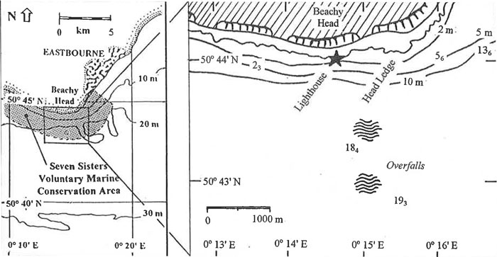
| Location: Between 0 and 1 km S & SE of the lighthouse | Other conservation designation?: No |
||||||
| Lat./Long. position of centre of site: 50° 43' 83" N 0° 14' 89" E |
OS grid ref. of centre of site: TV 586 947 |
Author: Robert Irving |
|||||
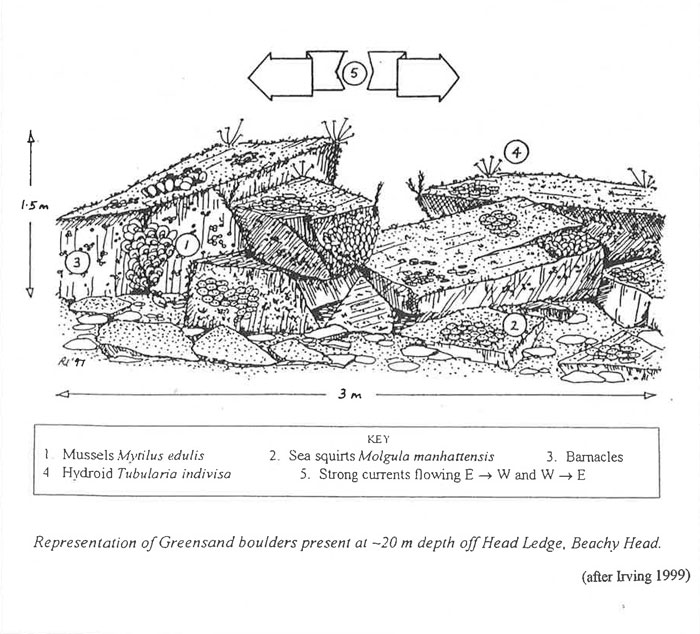
| Sea bed type: Chalk bedrock, mixed sediments, mussel beds and angular greensand boulders (off Head Ledge). |
Depth range (below chart datum): 7-25 m |
Date identified: June 2001 |
|||||
Summary
The seabed geology in the vicinity of Beachy Head is very varied, with chalk, gault clay and greensand all being present. The topography too is unusual, the 20 m depth contour coming to within 800 m of the shore in places, and the area is affected by strong currents. The Upper Greensand promontory of Head Ledge which extends out from the headland at Beachy Head, is a relatively hard sedimentary rock when compared to chalk, giving rise to different epifaunal communities being associated with it.
Biological Description
Head Ledge extends in a south-westerly direction beyond low water mark for almost 200 m, as a shallow ridge just below the surface. Strong tidal currents flow across the ridge creating turbulent water and overfalls. To the west of the ledge (as far as the lighthouse and then beyond that) is an area of sand. Besides greensand bedrock, Head Ledge comprises a jumble of angular greensand boulders which extend to a depth of at least 12 m BCD. The boulders may be up to 1 m in any dimension and there are many holes between them for small crustacea and fish to hide within. In shallow water their tops are dominated by red foliose algae, but in deeper water, both the tops and the sides are dominated by lowÂgrowing mats of the ascidian Molgula manhattensis and large numbers of both small mussels Mytilus edulis and barnacles. The horizontal and sloping surfaces of the boulders are often heavily silted. Further to the east, similar angular greensand boulders have been recorded embedded in muddy, clay-like sand (gault clay?) at 12 m BCD. Again the dominant cover on these boulders was of Molgula manhattensis and Mytilus edulis. A little to the west, extensive mussel beds have also been recorded in depths of 7-22 m BCD, often with predatory starfish Asterias rubens being present too.
In deeper water (21-25 m BCD) to the SW of the headland, the gently sloping seabed is of small pebbles and cobbles of flint and chalk overlying piddock-bored chalk bedrock. Chalk is also present in shallower water too (7 m BCD), a little further to the east, where it appears mixed in with gault clay (it is sometimes difficult to distinguish these two 'soft' rock types). Where there are fissures or gaps in the chalk bedrock, or where there are pockets sheltered from the current, silt accumulates to form soft mud, 10 cm or more deep. Other organisms recorded from here include encrusting sponges, bushy hydroids and bryozoans, and the anemones Actinothoe sphyrodeta and Urticina felina.
It is interesting to note that some 200-300 m off Beachy Head, SEASEARCH dive 715/28 (a drift dive) recorded five distinct seabed habitats at a depth of 7-9 m BCD, giving an indication of how rapidly the under1ying nature of the seabed changes within this area.
Justification
The varied geology and topography, strong tidal streams and depth of water close to the shore, all contribute to an unusual mix of environmental conditions within the vicinity of Beachy Head, which leads to the area being of particular marine biological interest.
References:Irving, R. A. 1998. Sussex Marine Life - an identification guide for divers East Sussex Council, Lewes |
|||||||
| Sussex SEASEARCH dive nos.: 714/114, 715/25-28 | |||||||
Site Location
Diagrammatic representation of site: Beachy Head

:Link to this page
Copyright Sussex Biodiversity Records Centre © 2025