SUSSEX MARINE SITES OF NATURE CONSERVATION IMPORTANCE
| Site: Outer Owers | Ref. No. 15 | ||||||
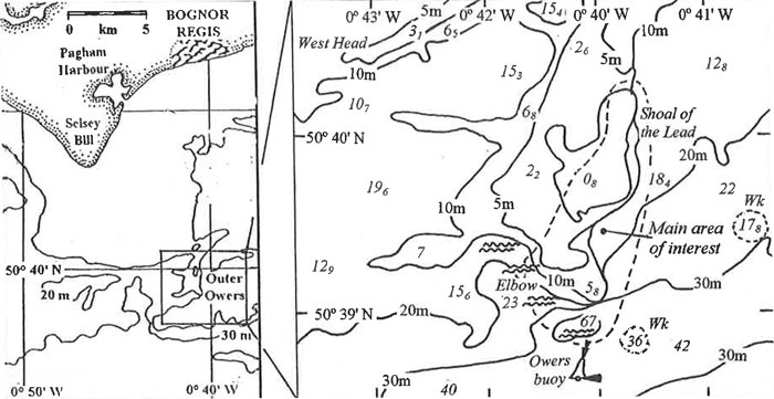
| Location: 8-10 km SE of Selsey Bill (includes the Elbow and the Shoal of the Lead) | Other conservation designation?: No |
||||||
| Lat./Long. position of centre of site: 50° 39' 50" N 0° 41' 0" W |
OS grid ref. of centre of site: |
Author: Robert Irving |
|||||
| Sea bed type: Shallow (to deep) mixed substrata with limestone bedrock, boulders & mudstone on a tide-swept gravel slope. |
Depth range (below chart datum): 5-40 m |
Date identified: June 2001 |
|||||
Summary
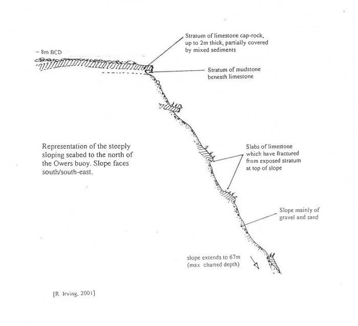
The Outer Owers consists of an extensive area of mostly shallow ground lying 8-10 km to the south-east of Selsey Bill, and includes the following features marked on charts: West Head, East Bank, and the Elbow. Within this triangle lie East Borough Head and the Shoal of the Lead. The area consists of a number of rock exposures (of both bedrock and boulders), interspersed by areas of mixed sediments. The area is affected by strong tidal currents, especially close to the Outer Owers buoy (at the southern edge of the area) and the Shoal of the Lead (on the east). Here the seabed drops away very rapidly, forming a steep slope of broken limestone cap-rock, mudstone and gravel, from 0 m to 67 m BCD.
Biological Description
The top of the reef known as the Shoal of the Lead consists of a horizontal exposure of limestone similar to that found at the Hounds, to the west of Selsey Bill. The main limestone 'sheet' is about 2 m thick, overlain by more broken slabs of limestone of lesser thickness, typically 30-50 cm thick. The limestone layers are sandwiched between layers of hard clay or mudstone. As the mudstone is eroded by the strong water movements which affect the site (and possibly by fishing gear?), the limestone slabs are left exposed. Eventually these break off and slide down the steep gravel and sand slope as large, flat boulder slabs.
Once stable, the upper surfaces of the slabs gradually become colonised by a low-growing hydroid-bryozoan turf, with occasional anemones, such as Actinothoe sphyrodeta, erect hydroids and encrusting sponges. In shallow depths, algae are the dominant cover organisms. The deepest depth at which foliose red algae have been found here is 15.7 m BCD (an unidentified species), and the deepest for brown algae is 10.1 m BCD (Dictyota dichotoma). Some sediment is present on the surface of the boulders, presumably swept down from above. The mudstone cobbles are riddled by piddock holes (SEASEARCH record 716/23). To the north-east of the aforementioned site, an extensive area of broken slipper limpet and oyster shells has been recorded (SEASEARCH record 716/26). The seabed here at 27 m BCD was described as resembling 'ploughed furrows', possibly caused by towed fishing gear but also the result of strong currents. Little marine life was associated with this habitat, with just hermit crabs, sand mason worms and spider crabs being recorded. A similar area of seabed at 28 m BCD, dominated by shell fragments but with little marine life, has been recorded to the SE of here (SEASEARCH record 716/30).
Justification
Exposed sublittoral limestone strata are rarely encountered off Sussex, most of the reefs being formed of sandstone or chalk. Other occurrences of limestone cap-rock are found at the Hounds reef (to the W of Selsey Bill - mSNCI Ref. No. 13) and on scattered, isolated 'mushroom-like' formations in Bracklesham Bay. Within the Outer Owers mSNCI area is the deepest area of seabed within 10 km of the Sussex coast (at 67 m BCD), and the steep cliff-like slope forms a unique physiographic feature.
References:Irving, R. A. 1998. Sussex Marine Life - an identification guide for divers East Sussex Council, Lewes |
|||||||
| Sussex SEASEARCH dive nos.: 716/23, 26, 28 & 30 | |||||||
| Sussex Sublittoral Survey site no.: 83/10, 23 | |||||||
Site Location
Diagrammatic representation of site: Outer Owers

:Link to this page
Copyright Sussex Biodiversity Records Centre © 2025